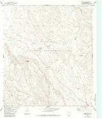
1983 Map of Black Gap
USGS Topo · Published 1984About this map
Black Gap Wildlife Management Area dominates this Brewster County landscape, revealing a transition from low-lying creek beds to massive mountain ranges. The map traces the rugged topography of the Sierra del Carmen and Sierra Larga, where the high peak of Stairway Mountain overlooks the drainage of Maravillas Creek. The remote nature of the region is evident in the sparse human infrastructure, consisting primarily of the Headquarters at Black Gap, several isolated Water Tanks, and a series of Jeep Trails and a Landing Strip for access.
Find a feature on this map
18 named features on this map. Tap any name to fly to it.
Don’t see what you’re looking for? This feature index may not catch every label — zoom into the map to look around manually.
Map Details
Editions of this 1983 Black Gap Map
This is the sole edition of this map. No revisions or reprints were ever made.
Other maps of this area

1903 · Chisos Mountains
USGS Topo · 1:125,000

1905 · Chisos Mountains
USGS Topo · 1:125,000

1917 · Bone Spring
USGS Topo · 1:62,500

1918 · Bone Spring
USGS Topo · 1:125,000

1918 · Bone Spring
USGS Topo · 1:62,500

1919 · Maravillas Canyon
USGS Topo · 1:62,500

1920 · Bone Spring
USGS Topo · 1:62,500

1930 · Stillwell Creek
USGS Topo · 1:62,500

1959 · Emory Peak
USGS Topo · 1:250,000

1965 · Emory Peak
USGS Topo · 1:250,000