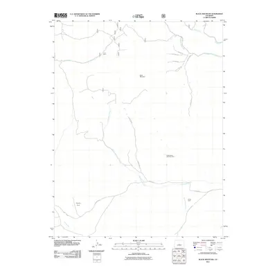
2011 Map of Black Mountain
USGS Topo · Published 2011About this map
Poncha Park and its surrounding high-altitude drainage systems define this 2011 survey of the Fremont County landscape. The area is characterized by scattered ranching operations, including the VVN Ranch in the north and Stirrup Ranch to the southeast. The terrain rises sharply toward Black Mountain and the Big Horn Rdg, where seasonal runoff feeds an intricate network of watercourses. Major drainages like Cottonwood Creek and North Waugh Creek carve through the foothills, while the Cottonwood Detention Dam 1 indicates modern water management efforts within this rangeland. Historically significant trails and local transit routes, such as the Buckhorn Tr and County Rd 2, provide the primary access to these remote reaches of the Colorado backcountry, connecting isolated homesteads to the broader region.
Find a feature on this map
21 named features on this map. Tap any name to fly to it.
Don’t see what you’re looking for? This feature index may not catch every label — zoom into the map to look around manually.
Map Details
Editions of this 2011 Black Mountain Map
This is the sole edition of this map. No revisions or reprints were ever made.
Other maps of this area

1954 · Pueblo
USGS Topo · 1:250,000

1956 · Cameron Mountain
USGS Topo · 1:62,500

1957 · Pueblo
USGS Topo · 1:250,000

1958 · Pueblo
USGS Topo · 1:250,000

1959 · Antero Reservoir
USGS Topo · 1:62,500

1959 · Black Mountain
USGS Topo · 1:62,500

1959 · Guffey
USGS Topo · 1:62,500

1962 · Pueblo
USGS Topo · 1:250,000

1966 · Pueblo
USGS Topo · 1:250,000
1983 · Jack Hall Mountain
USGS Topo · 1:24,000