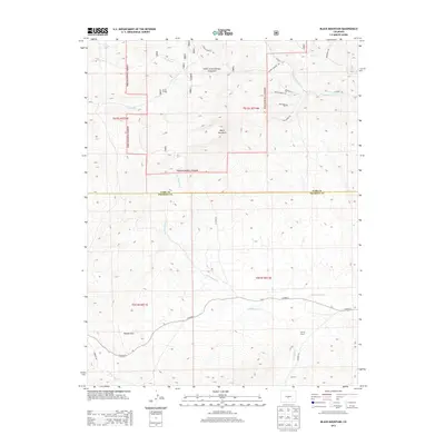
2013 Map of Black Mountain
USGS Topo · Published 2013About this map
Black Mountain anchors this high-elevation landscape where the border of the Pike National Forest meets the working lands of the central Colorado high country. The map illustrates a transition from the protected forest terrain to private ranching operations, including the V V N Ranch in the north and the Stirrup Ranch to the south. Water sources are critical to this environment, defined by the winding paths of Cottonwood Creek and the headwaters of Thirtyone Mile Creek. The drainage patterns, including the marshy Rye Slough and the seasonal flow of Gribbles Run, reveal how the local topography has historically dictated the placement of homesteads and grazing boundaries. Surveyed roads such as County Road 2 and County Road F5 connect these dispersed ranching sites, tracing the routes that maintain communication across the Park and Fremont County line.
Find a feature on this map
28 named features on this map. Tap any name to fly to it.
Don’t see what you’re looking for? This feature index may not catch every label — zoom into the map to look around manually.
Map Details
Editions of this 2013 Black Mountain Map
This is the sole edition of this map. No revisions or reprints were ever made.
Other maps of this area

1954 · Pueblo
USGS Topo · 1:250,000

1956 · Cameron Mountain
USGS Topo · 1:62,500

1957 · Pueblo
USGS Topo · 1:250,000

1958 · Pueblo
USGS Topo · 1:250,000

1959 · Antero Reservoir
USGS Topo · 1:62,500

1959 · Black Mountain
USGS Topo · 1:62,500

1959 · Guffey
USGS Topo · 1:62,500

1962 · Pueblo
USGS Topo · 1:250,000

1966 · Pueblo
USGS Topo · 1:250,000
1983 · Jack Hall Mountain
USGS Topo · 1:24,000