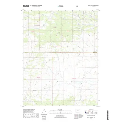
2019 Map of Black Mountain
USGS Topo · Published 2019About this map
Pike National Forest dominates the northern landscape of this quadrangle, where the high-altitude terrain is defined by the prominent Black Mtn and the distinct spine of Bighorn Ridge. This area, straddling the border of Park and Fremont counties, showcases a complex drainage system feeding into watercourses like Rye Slough and Thirtyone Mile Cr. To the south, Poncha Park provides a notable clearing amidst the topography, surrounded by a network of rural routes such as Co RD 2 and Co RD 11. The mapping reflects a modern era of land management, where local roads like Bugler Ln and Elk Height Ln provide access to the foothills. For those studying the hydrology of the central Colorado high country, the headwaters of Cottonwood Cr and Gribbles Run illustrate the seasonal flow patterns that shape this environment.
Find a feature on this map
28 named features on this map. Tap any name to fly to it.
Don’t see what you’re looking for? This feature index may not catch every label — zoom into the map to look around manually.
Map Details
Editions of this 2019 Black Mountain Map
This is the sole edition of this map. No revisions or reprints were ever made.
Other maps of this area

1954 · Pueblo
USGS Topo · 1:250,000

1956 · Cameron Mountain
USGS Topo · 1:62,500

1957 · Pueblo
USGS Topo · 1:250,000

1958 · Pueblo
USGS Topo · 1:250,000

1959 · Antero Reservoir
USGS Topo · 1:62,500

1959 · Black Mountain
USGS Topo · 1:62,500

1959 · Guffey
USGS Topo · 1:62,500

1962 · Pueblo
USGS Topo · 1:250,000

1966 · Pueblo
USGS Topo · 1:250,000
1983 · Jack Hall Mountain
USGS Topo · 1:24,000