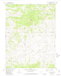
1983 Map of Black Mountain
USGS Topo · Published 1983About this map
Pike National Forest dominates the upper portion of this 1983 topographic study, where the prominent peak of Black Mountain overlooks a landscape defined by significant drainage networks. The map details the transition across the Park Co Fremont Co line, capturing the isolated settlement of Poncha Park and the Stirrup Ranch further east. A complex system of watercourses, including Thirtyone Mile Creek, Cottonwood Creek, and Paris Creek, dictates the movement across this terrain, supplemented by the distinct Rye Slough and North Waugh Creek. For those interested in historical land use and early resource extraction, the sheet is peppered with several Prospect and Prospects labels, alongside a network of Jeep Trails and unnamed routes that indicate a history of exploration and ranching activity through Gribbles Run.
Find a feature on this map
14 named features on this map. Tap any name to fly to it.
Don’t see what you’re looking for? This feature index may not catch every label — zoom into the map to look around manually.
Map Details
Editions of this 1983 Black Mountain Map
This is the sole edition of this map. No revisions or reprints were ever made.
Other maps of this area

1954 · Pueblo
USGS Topo · 1:250,000

1956 · Cameron Mountain
USGS Topo · 1:62,500

1957 · Pueblo
USGS Topo · 1:250,000

1958 · Pueblo
USGS Topo · 1:250,000

1959 · Antero Reservoir
USGS Topo · 1:62,500

1959 · Black Mountain
USGS Topo · 1:62,500

1959 · Guffey
USGS Topo · 1:62,500

1962 · Pueblo
USGS Topo · 1:250,000

1966 · Pueblo
USGS Topo · 1:250,000
1983 · Jack Hall Mountain
USGS Topo · 1:24,000