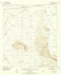
1955 Map of Black Mountains
USGS Topo · Published 1956About this map
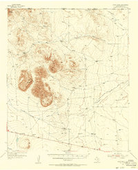
Salt Flat serves as the primary outpost in this arid Hudspeth County landscape, situated near the Salt Ponds and a beacon at the edge of the desert. The 1955 survey illustrates a ranching economy reliant on an extensive network of water infrastructure, including the Eightmile Windmill, McAdoo Tank, and Kuykendall Tank. These features represent the essential lifelines for isolated settlements like Babb Camp and the Big Tank Ranch.
Find a feature on this map
49 named features on this map. Tap any name to fly to it.
Don’t see what you’re looking for? This feature index may not catch every label — zoom into the map to look around manually.
Map Details
Editions of this 1955 Black Mountains Map
This is the sole edition of this map. No revisions or reprints were ever made.
Other maps of this area

1895 · Sierra Blanca
USGS Topo · 1:125,000

1906 · Van Horn
USGS Topo · 1:125,000

1933 · Guadalupe Peak
USGS Topo · 1:48,000

1940 · Guadalupe Peak
USGS Topo · 1:62,500
1948 · Triple Hill
USGS Topo · 1:62,500
1951 · Dell City
USGS Topo · 1:62,500
1951 · Red Hills
USGS Topo · 1:62,500

1954 · Van Horn
USGS Topo · 1:250,000
1955 · Cerro Diablo
USGS Topo · 1:62,500

1958 · Van Horn
USGS Topo · 1:250,000