
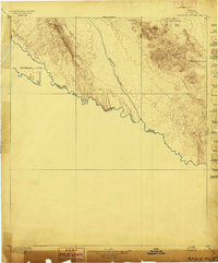
1895 Map of Sierra Blanca
USGS Topo · Published 1895About this map
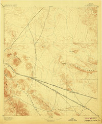
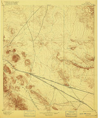
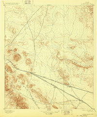
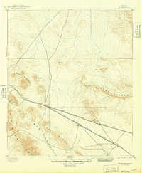
The junction of the Texas and Pacific Railroad and the Galveston Harrisburg and San Antonio Railroad defines this late nineteenth-century portrait of Trans-Pecos Texas. Centered on the railroad hub at Sierra Blanca, the landscape is a complex of high desert peaks and strategic mountain passes. To the west, the Sierra Blanca mountains and the Quitman Mountains flank the rail lines, while the Sierra Diablo dominates the eastern horizon. The presence of features like S.P. Well and isolated settlements such as Etholen and Arispe highlights the critical importance of water and steam-engine infrastructure in this arid environment. This 1891 survey, published by geographer R.U. Goode, traces the rugged geometry of the Devils Canyon and the surrounding limestone ridges before the modern highway system bypassed these historic rail-stop coordinates.
Find a feature on this map
19 named features on this map. Tap any name to fly to it.
Don’t see what you’re looking for? This feature index may not catch every label — zoom into the map to look around manually.
Map Details
Editions of this 1895 Sierra Blanca Map
5 editions found
Other maps of this area

1892 · Chispa
USGS Topo · 1:125,000

1894 · Fort Hancock
USGS Topo · 1:125,000

1895 · Chispa
USGS Topo · 1:125,000
1897 · Eagle Mountain
USGS Topo · 1:125,000

1897 · Chispa
USGS Topo · 1:125,000

1903 · Cerro Alto
USGS Topo · 1:125,000

1906 · Van Horn
USGS Topo · 1:125,000

1916 · Eagle Mountain
USGS Topo · 1:125,000

1943 · Fort Quitman
USGS Topo · 1:62,500
1943 · Tepee Butte
USGS Topo · 1:62,500