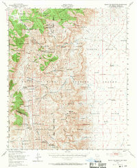
1948 Map of Black Top Mountain
USGS Topo · Published 1970About this map
White Sands Proving Ground and the Alamogordo Bombing Range dominate this landscape during the early Cold War era, illustrating the post-war transition of Sierra County into a restricted military testing zone. The map documents numerous family-run cattle operations caught within these boundaries, including the Miller Ranch Headquarters, Wool Ranch Headquarters, and the Frank Crockett Ranch Headquarters.
Find a feature on this map
98 named features on this map. Tap any name to fly to it.
Don’t see what you’re looking for? This feature index may not catch every label — zoom into the map to look around manually.
Map Details
Editions of this 1948 Black Top Mountain Map
3 editions found

Other maps of this area

1916 · Tonuco
USGS Topo · 1:125,000

1916 · Salinas Peak
USGS Topo · 1:125,000

1916 · Tularosa
USGS Topo · 1:125,000

1916 · Point Of Sands
USGS Topo · 1:125,000

1932 · Tonuco
USGS Topo · 1:125,000

1947 · Point Of Sands 2
USGS Topo · 1:62,500

1947 · Capitol Peak
USGS Topo · 1:62,500

1948 · Sowell
USGS Topo · 1:62,500

1948 · Chicken Well
USGS Topo · 1:62,500

1948 · Malpais Well
USGS Topo · 1:62,500