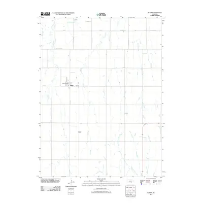
2011 Map of Bladen
USGS Topo · Published 2011About this map
Bladen serves as the central hub for this portion of Webster County, situated at the intersection of several local thoroughfares including W Main St and Nebraska St. The village is anchored by the Bladen Post Office and the nearby East Lawn Cemetery, surrounded by a vast grid of section roads like S Bladen Ave and W Blue Valley Rd. The landscape is defined by the drainage of several watercourses, most notably the Little Blue River in the northwest corner and the southward-flowing Flat Creek, Rabbit Run Creek, and West Fork Elm Creek. Local history and genealogy are preserved in the outlying Cloverton Cemetery and Plainview Cemetery, which mark the rural surroundings beyond the town center. At the northern edge, the Lewis Dam creates the Lewis Reservoir, a significant man-made water feature within this agricultural prairie environment.
Find a feature on this map
25 named features on this map. Tap any name to fly to it.
Don’t see what you’re looking for? This feature index may not catch every label — zoom into the map to look around manually.
Map Details
Editions of this 2011 Bladen Map
This is the sole edition of this map. No revisions or reprints were ever made.
Other maps of this area

1897 · Red Cloud
USGS Topo · 1:125,000

1898 · Superior
USGS Topo · 1:125,000

1940 · Red Cloud
USGS Topo · 1:62,500

1942 · Red Cloud
USGS Topo · 1:62,500

1955 · Grand Island
USGS Topo · 1:250,000

1957 · Grand Island
USGS Topo · 1:250,000

1958 · Grand Island
USGS Topo · 1:250,000

1969 · Blue Hill
USGS Topo · 1:24,000
1969 · Holstein
USGS Topo · 1:24,000
1969 · Roseland
USGS Topo · 1:24,000