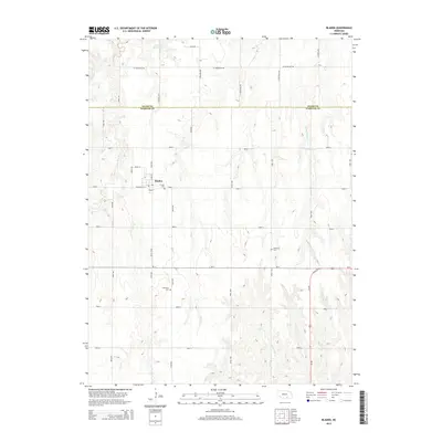
2014 Map of Bladen
USGS Topo · Published 2014About this map
Bladen serves as the primary hub of this rural landscape where Webster and Adams counties meet. The settlement is defined by a grid including N Main St and N Railroad St, hinting at its historical development alongside the rail corridor. The surrounding agricultural lands are divided by a precise network of section-line roads, such as W Silverlake Rd and Road Y, which navigate the drainages of the Little Blue River and several small creeks.
Find a feature on this map
37 named features on this map. Tap any name to fly to it.
Don’t see what you’re looking for? This feature index may not catch every label — zoom into the map to look around manually.
Map Details
Editions of this 2014 Bladen Map
This is the sole edition of this map. No revisions or reprints were ever made.
Other maps of this area

1897 · Red Cloud
USGS Topo · 1:125,000

1898 · Superior
USGS Topo · 1:125,000

1940 · Red Cloud
USGS Topo · 1:62,500

1942 · Red Cloud
USGS Topo · 1:62,500

1955 · Grand Island
USGS Topo · 1:250,000

1957 · Grand Island
USGS Topo · 1:250,000

1958 · Grand Island
USGS Topo · 1:250,000

1969 · Blue Hill
USGS Topo · 1:24,000
1969 · Holstein
USGS Topo · 1:24,000
1969 · Roseland
USGS Topo · 1:24,000