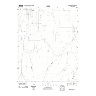
2010 Map of Blanding South
USGS Topo · Published 2010About this map
Blanding anchors the northern edge of this Utah landscape, serving as a gateway to the high desert terrain of San Juan County. The topography is dominated by the broad, flat expanses of White Mesa and Mustang Mesa, which are dissected by deep drainage systems such as Recapture Creek, Westwater Creek, and Corral Creek. To the south, the terrain becomes increasingly complex as the mesas break into distinctive landmarks like Murphy Point and Shumway Point, overlooking canyons including Road Canyon and Ute Canyon.
Find a feature on this map
34 named features on this map. Tap any name to fly to it.
Don’t see what you’re looking for? This feature index may not catch every label — zoom into the map to look around manually.
Map Details
Editions of this 2010 Blanding South Map
This is the sole edition of this map. No revisions or reprints were ever made.
Other maps of this area

1886 · Abajo
USGS Topo · 1:250,000

1892 · Abajo
USGS Topo · 1:250,000

1893 · Abajo
USGS Topo · 1:250,000

1935 · Elk Ridge
USGS Topo · 1:96,000

1940 · Elk Ridge
USGS Topo · 1:125,000

1955 · Verdure 3 SE
USGS Topo · 1:24,000

1955 · Verdure 3 NE
USGS Topo · 1:24,000

1956 · Cortez
USGS Topo · 1:250,000
1957 · Elk Ridge 4 NE
USGS Topo · 1:24,000

1957 · Elk Ridge 4 SE
USGS Topo · 1:24,000