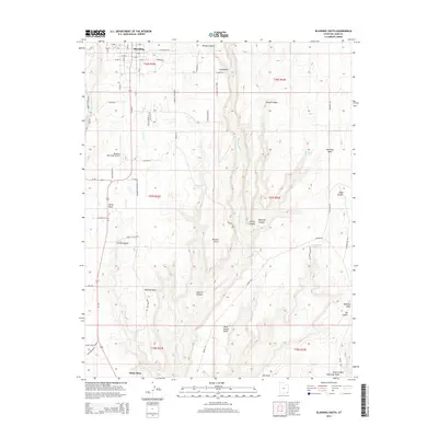
2014 Map of Blanding South
USGS Topo · Published 2014About this map
Blanding serves as the focal point of this San Juan County survey, showing the southern reaches of the settlement and its infrastructure in the early 21st century. The landscape is defined by the dramatic drainage patterns of Recapture Cr and its many tributary canyons, including Jennys Canyon and Mustang Canyon. These deep incisions into the red rock plateaus separate prominent landmarks like Mustang Mesa and Ute Point. Modern aviation and transportation are represented by the Blanding Municipal Airport and the junction of Ut-95, while more remote sites like Mustang Spring and Richmond Spring indicate the critical locations of water in this arid environment. The map details a transition from the structured street grid of the town to the expansive, canyon-broken tablelands to the south, marked by numerous named overlooks such as Browns Point and Murphy Point.
Find a feature on this map
65 named features on this map. Tap any name to fly to it.
Don’t see what you’re looking for? This feature index may not catch every label — zoom into the map to look around manually.
Map Details
Editions of this 2014 Blanding South Map
This is the sole edition of this map. No revisions or reprints were ever made.
Other maps of this area

1886 · Abajo
USGS Topo · 1:250,000

1892 · Abajo
USGS Topo · 1:250,000

1893 · Abajo
USGS Topo · 1:250,000

1935 · Elk Ridge
USGS Topo · 1:96,000

1940 · Elk Ridge
USGS Topo · 1:125,000

1955 · Verdure 3 SE
USGS Topo · 1:24,000

1955 · Verdure 3 NE
USGS Topo · 1:24,000

1956 · Cortez
USGS Topo · 1:250,000
1957 · Elk Ridge 4 NE
USGS Topo · 1:24,000

1957 · Elk Ridge 4 SE
USGS Topo · 1:24,000