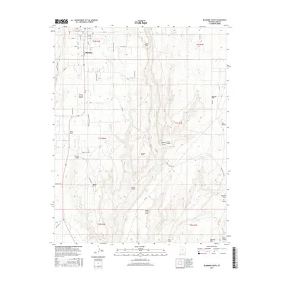
2017 Map of Blanding South
USGS Topo · Published 2017About this map
Blanding sits at the northern edge of this high desert landscape, where the street grid of S Main St and W 400 S quickly transitions into the canyon-carved terrain of San Juan County. The southern expansion of the community is anchored by the Blanding Municipal Airport and the settlement of White Mesa further south along the highway. To the east, the deep drainage of Recapture Creek defines the local topography, separating the town from the elevated Mustang Mesa. A unique historical marker, Posey S Last Shot, is noted near Corral Canyon, signifying local lore and conflict. The map traces a network of remote routes like Around the World Rd and Mustang, which connect isolated water sources including Mustang Spring and Richmond Spring across the high-altitude plateaus and points.
Find a feature on this map
63 named features on this map. Tap any name to fly to it.
Don’t see what you’re looking for? This feature index may not catch every label — zoom into the map to look around manually.
Map Details
Editions of this 2017 Blanding South Map
This is the sole edition of this map. No revisions or reprints were ever made.
Other maps of this area

1886 · Abajo
USGS Topo · 1:250,000

1892 · Abajo
USGS Topo · 1:250,000

1893 · Abajo
USGS Topo · 1:250,000

1935 · Elk Ridge
USGS Topo · 1:96,000

1940 · Elk Ridge
USGS Topo · 1:125,000

1955 · Verdure 3 SE
USGS Topo · 1:24,000

1955 · Verdure 3 NE
USGS Topo · 1:24,000

1956 · Cortez
USGS Topo · 1:250,000
1957 · Elk Ridge 4 NE
USGS Topo · 1:24,000

1957 · Elk Ridge 4 SE
USGS Topo · 1:24,000