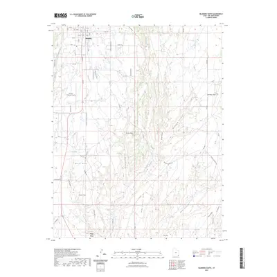
2023 Map of Blanding South
USGS Topo · Published 2023About this map
The settlement of Blanding anchors the northern edge of this Utah landscape, where residential streets like W 100 S and E Harris Ln give way to the expansive canyon country of San Juan County. To the south, the community of White Mesa sits atop the landform for which it is named, situated along the corridor established by S Main St. This area is characterized by a dramatic series of north-south drainages, most notably Recapture Creek and Mustang Canyon, which carve deep incisions through the high desert floor.
Find a feature on this map
58 named features on this map. Tap any name to fly to it.
Don’t see what you’re looking for? This feature index may not catch every label — zoom into the map to look around manually.
Map Details
Editions of this 2023 Blanding South Map
This is the sole edition of this map. No revisions or reprints were ever made.
Other maps of this area

1886 · Abajo
USGS Topo · 1:250,000

1892 · Abajo
USGS Topo · 1:250,000

1893 · Abajo
USGS Topo · 1:250,000

1935 · Elk Ridge
USGS Topo · 1:96,000

1940 · Elk Ridge
USGS Topo · 1:125,000

1955 · Verdure 3 SE
USGS Topo · 1:24,000

1955 · Verdure 3 NE
USGS Topo · 1:24,000

1956 · Cortez
USGS Topo · 1:250,000
1957 · Elk Ridge 4 NE
USGS Topo · 1:24,000

1957 · Elk Ridge 4 SE
USGS Topo · 1:24,000