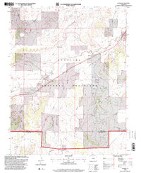
1996 Map of Bloom
USGS Topo · Published 2000About this map
The Santa Fe National Historic Trail cuts through this high plains landscape, following the general path of Timpas Creek as it moves toward the settlement of Bloom. This 1996 revision of the topography captures a rural region dominated by the Comanche National Grassland, where water management defines the human footprint. A dense network of reservoirs, such as South Lambing Camp Reservoir, Danifer Reservoir, and Fultz Reservoir, supports the ranching economy across the Bloom Hills. Small markers of local history appear at Mindeman and the Graves near Iron Springs. The presence of numerous named windmills, including the Bloom Hill Windmill and Hedgecock Windmill, alongside remote Landing Strips, illustrates the isolation and specialized infrastructure required for life on these Colorado grasslands late in the twentieth century.
Find a feature on this map
44 named features on this map. Tap any name to fly to it.
Don’t see what you’re looking for? This feature index may not catch every label — zoom into the map to look around manually.
Map Details
Editions of this 1996 Bloom Map
This is the sole edition of this map. No revisions or reprints were ever made.
Other maps of this area

1891 · Timpas
USGS Topo · 1:125,000

1891 · Apishapa
USGS Topo · 1:125,000

1893 · Apishapa
USGS Topo · 1:125,000

1894 · Timpas
USGS Topo · 1:125,000

1897 · Apishapa
USGS Topo · 1:125,000

1954 · Trinidad
USGS Topo · 1:250,000

1955 · La Junta
USGS Topo · 1:250,000

1955 · Trinidad
USGS Topo · 1:250,000

1958 · La Junta
USGS Topo · 1:250,000

1958 · Trinidad
USGS Topo · 1:250,000