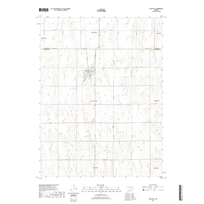
2017 Map of Blue Hill
USGS Topo · Published 2017About this map
Blue Hill serves as the central hub of this agricultural landscape in southern Nebraska, where the grid-like road system of Webster Co meets the southern edge of Adams Co. The town is well-supported by community landmarks including the Blue Hill Cem, while rural burial grounds like Trinity Cem to the north and Walker Cem to the south mark the surrounding countryside. This region is characterized by an extensive network of water management features, including the Schmidt Reservoir, Siebrass Reservoir, and Seeman Reservoir, which are vital for local land use. These man-made basins are integrated into the natural drainage basins of Ash Cr, Dove Cr, and Elm Cr. The map details the transition from town streets such as W Cass ST and W Saline ST to the expansive rural sections defined by Blue Valley RD and the various numbered range lines.
Find a feature on this map
34 named features on this map. Tap any name to fly to it.
Don’t see what you’re looking for? This feature index may not catch every label — zoom into the map to look around manually.
Map Details
Editions of this 2017 Blue Hill Map
This is the sole edition of this map. No revisions or reprints were ever made.
Other maps of this area

1897 · Red Cloud
USGS Topo · 1:125,000

1898 · Superior
USGS Topo · 1:125,000

1940 · Red Cloud
USGS Topo · 1:62,500

1942 · Red Cloud
USGS Topo · 1:62,500

1955 · Grand Island
USGS Topo · 1:250,000

1957 · Grand Island
USGS Topo · 1:250,000

1958 · Grand Island
USGS Topo · 1:250,000

1969 · Lawrence
USGS Topo · 1:24,000

1969 · Blue Hill
USGS Topo · 1:24,000
1969 · Roseland
USGS Topo · 1:24,000