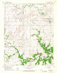
1966 Map of Blue Mound
USGS Topo · Published 1967About this map
Blue Mound serves as the focal point of this Eastern Kansas landscape, positioned where the high ground drops toward the drainage basins of the Osage River and Little Osage River. During the mid-1960s, the area's infrastructure was defined by a transition from older transit systems to modern utilities, evidenced by an Old Railroad Grade running northwest to southeast, now bypassed by Kansas 31 and a long-distance Pipeline. Local history is deeply rooted in the rural landscape, with numerous family and community burial grounds such as Sunny Slope Cem and Pleasant View Cem distributed near the town site. An active Oil Field and a Quarry near the Linn and Bourbon County line indicate the mid-century industrial footprint, while the Blue Mound Reservoir and its Picnic Area highlight the development of local water resources and recreation.
Find a feature on this map
30 named features on this map. Tap any name to fly to it.
Don’t see what you’re looking for? This feature index may not catch every label — zoom into the map to look around manually.
Map Details
Editions of this 1966 Blue Mound Map
This is the sole edition of this map. No revisions or reprints were ever made.
Other maps of this area

1884 · Fort Scott
USGS Topo · 1:125,000

1885 · Garnett
USGS Topo · 1:125,000

1886 · Iola
USGS Topo · 1:125,000

1886 · Fort Scott
USGS Topo · 1:125,000

1887 · Mound City
USGS Topo · 1:125,000

1893 · Fort Scott
USGS Topo · 1:125,000

1893 · Iola
USGS Topo · 1:125,000

1893 · Mound City
USGS Topo · 1:125,000

1894 · Garnett
USGS Topo · 1:125,000

1904 · Iola
USGS Topo · 1:125,000