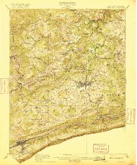
1916 Map of Bluefield
USGS Topo · Published 1916About this map
Princeton and the coal-driven rail corridors of the Norfolk and Western Railway define this detailed survey of Mercer County and the Virginia borderlands. The landscape is defined by the steep ridges of Flat Top Mountain and East River Mountain, which dictated the early infrastructure of the region. Dozens of rural schoolhouses are documented here, including Sand Gap School, Pinnacle School, and Willis White School, reflecting a densely populated rural landscape of small farming and mining communities.
Find a feature on this map
109 named features on this map. Tap any name to fly to it.
Don’t see what you’re looking for? This feature index may not catch every label — zoom into the map to look around manually.
Map Details
Editions of this 1916 Bluefield Map
This is the sole edition of this map. No revisions or reprints were ever made.
Other maps of this area

1887 · Pocahontas
USGS Topo · 1:125,000

1887 · Hinton
USGS Topo · 1:125,000

1890 · Dublin
USGS Topo · 1:125,000

1891 · Pocahontas
USGS Topo · 1:125,000

1891 · Dublin
USGS Topo · 1:125,000

1891 · Raleigh
USGS Topo · 1:125,000

1892 · Hinton
USGS Topo · 1:125,000

1894 · Pocahontas
USGS Topo · 1:125,000

1895 · Pocahontas
USGS Topo · 1:125,000

1897 · Raleigh
USGS Topo · 1:125,000