
1965 Map of Bluelight NW
USGS Topo · Published 1966About this map
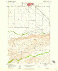
Agricultural development and irrigation infrastructure dominate this Yakima County landscape as it appeared in the mid-1960s. The engineered movement of water is central to the area's layout, anchored by the Satus No 3 Pumping Station and a system of waterways including the Satus No 2 Pump Canal and Satus No 3 Pump Canal. This network allowed for the expansion of farming into the arid terrain north of the prominent Rock Bluff escarpment.
Find a feature on this map
20 named features on this map. Tap any name to fly to it.
Don’t see what you’re looking for? This feature index may not catch every label — zoom into the map to look around manually.
Map Details
Editions of this 1965 Bluelight NW Map
This is the sole edition of this map. No revisions or reprints were ever made.
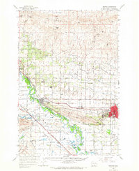
Other maps of this area

1910 · Zillah
USGS Topo · 1:125,000

1950 · Yakima
USGS Topo · 1:250,000
1958 · Hembre Mtn
USGS Topo · 1:24,000

1958 · Yakima
USGS Topo · 1:250,000

1961 · Yakima
USGS Topo · 1:250,000

1965 · Bluelight
USGS Topo · 1:24,000
1965 · Granger
USGS Topo · 1:62,500

1965 · Poisel Butte
USGS Topo · 1:62,500

1965 · Bluelight
USGS Topo · 1:62,500

1965 · Poisel Butte
USGS Topo · 1:24,000