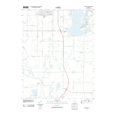
2009 Map of Boicourt
USGS Topo · Published 2009About this map
The Marais des Cygnes River meanders through this portion of Linn County, defining a landscape of complex hydrology and rural crossroads. The settlement of Boicourt sits near the river's bend, south of where North Sugar Creek and Middle Creek converge. The massive La Cygnes Lake dominates the northeast, its engineered shoreline contrasting with the natural oxbows of Boicourt Lake downstream. This 2009 survey reveals a mix of old pioneer landmarks and modern infrastructure, where US Hwy 69 passes near several historically named burial grounds, including Ninety Six Cemetery and East Mount Zion Cemetery. To the north, a dense network of residential streets such as Chieftain Dr and Foxwood Dr indicates suburban growth near La Cygne Corner, while the southern reaches remain dedicated to the river plains and traditional sites like the Trading Post Cemetery.
Find a feature on this map
46 named features on this map. Tap any name to fly to it.
Don’t see what you’re looking for? This feature index may not catch every label — zoom into the map to look around manually.
Map Details
Editions of this 2009 Boicourt Map
This is the sole edition of this map. No revisions or reprints were ever made.
Other maps of this area

1887 · Mound City
USGS Topo · 1:125,000

1893 · Mound City
USGS Topo · 1:125,000

1938 · Worland
USGS Topo · 1:24,000

1940 · Worland
USGS Topo · 1:24,000

1947 · Lawrence
USGS Topo · 1:250,000

1950 · Lawrence
USGS Topo · 1:250,000

1956 · Lawrence
USGS Topo · 1:250,000
1957 · Boicourt
USGS Topo · 1:24,000
1957 · New Lancaster
USGS Topo · 1:24,000

1958 · La Cygne
USGS Topo · 1:24,000