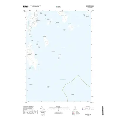
2021 Map of Bois Bubert
USGS Topo · Published 2021About this map
Bois Bubert Island and its surrounding archipelago define this coastal Maine landscape, where the waters of Narraguagus Bay and Pleasant Bay meet the open Atlantic Ocean. The map reveals a complex network of maritime navigation hazards and coastal landmarks, from the prominent Baldwin Head to isolated outcrops like Jordans Delight and Mackerel Rock. This modern survey details the rugged shoreline of Dyer Island and Flint Island, illustrating the sparse road infrastructure at Tom Leighton Point where Tom Leighton Point Rd and Stoehrs Way provide the primary access to the water. The presence of numerous named ledges and reefs, such as Trafton Island Ledge and Seal Cove Ledge, underscores the treacherous nature of these tidal reaches and protected harbors like Little Bois Bubert Harbor.
Find a feature on this map
54 named features on this map. Tap any name to fly to it.
Don’t see what you’re looking for? This feature index may not catch every label — zoom into the map to look around manually.
Map Details
Editions of this 2021 Bois Bubert Map
This is the sole edition of this map. No revisions or reprints were ever made.
Other maps of this area

1902 · Cherryfield
USGS Topo · 1:62,500

1904 · Cherryfield
USGS Topo · 1:62,500

1904 · Petit Manan
USGS Topo · 1:62,500

1921 · Great Wass Island
USGS Topo · 1:62,500

1921 · Columbia Falls
USGS Topo · 1:62,500

1941 · Columbia Falls
USGS Topo · 1:62,500

1942 · Cherryfield
USGS Topo · 1:62,500

1942 · Columbia Falls
USGS Topo · 1:62,500

1948 · Drisko Island
USGS Topo · 1:24,000
1948 · Petit Manan
USGS Topo · 1:24,000