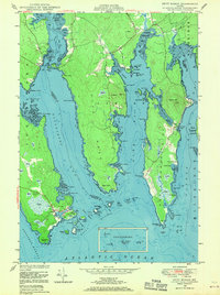
1948 Map of Petit Manan
USGS Topo · Published 1970About this map
Corea serves as the primary coastal settlement on this jagged stretch of the Maine shoreline, where the Atlantic tide reaches deep into the land through Gouldsboro Bay and Dyer Bay. The map reveals a landscape defined by saltwater incursions and freshwater heaths, with Corea Harbor and Steuben Hbr anchoring the maritime economy of the mid-century. Genealogists can locate the Corea Cem and a prominent Spire near the town center, while local historians may find interest in the Carrying Place Cove—a name signifying the historical practice of portaging between water bodies. The terrain is marked by numerous islands and ledges, including Lobster Island and Sally Island, situated between Western Passage and Frazer Passage, illustrating the complex navigation required by locals before the era of modern improvements.
Find a feature on this map
103 named features on this map. Tap any name to fly to it.
Don’t see what you’re looking for? This feature index may not catch every label — zoom into the map to look around manually.
Map Details
Editions of this 1948 Petit Manan Map
3 editions found
Other maps of this area

1902 · Cherryfield
USGS Topo · 1:62,500

1904 · Cherryfield
USGS Topo · 1:62,500

1904 · Bar Harbor
USGS Topo · 1:62,500

1904 · Petit Manan
USGS Topo · 1:62,500

1930 · Tunk Lake
USGS Topo · 1:48,000

1932 · Tunk Lake
USGS Topo · 1:62,500

1942 · Bar Harbor
USGS Topo · 1:62,500

1942 · Cherryfield
USGS Topo · 1:62,500

1942 · Tunk Lake
USGS Topo · 1:62,500

1948 · Bangor
USGS Topo · 1:250,000