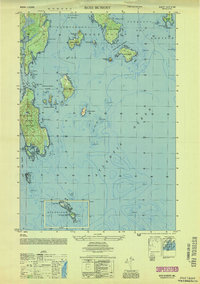
1953 Map of Bois Bubert
USGS Topo · Published 1953About this map
Bois Bubert Island and the neighboring archipelago of the Narraguagus Bay region define this mid-century coastal survey. The map details a complex maritime environment where land and sea interlock, featuring prominent landmarks like Pigeon Hill and the long expanse of Dyer Island. Navigational aids, including the Trafton Halftide Beacon and a Day Beacon in the open Atlantic Ocean, highlight the area's importance to coastal seafaring. Small harbors and coves, such as Seal Cove and Little Bois Bubert Harbor, suggest a landscape shaped by small-boat fishing and coastal trade rather than large-scale industrialization. The intricate bathymetry and named hazards like Pot Rock and Mackerel Rock provide essential context for understanding the historic maritime risks of the Addison and Milbridge shorelines.
Find a feature on this map
55 named features on this map. Tap any name to fly to it.
Don’t see what you’re looking for? This feature index may not catch every label — zoom into the map to look around manually.
Map Details
Editions of this 1953 Bois Bubert Map
This is the sole edition of this map. No revisions or reprints were ever made.
Other maps of this area

1902 · Cherryfield
USGS Topo · 1:62,500

1904 · Cherryfield
USGS Topo · 1:62,500

1904 · Petit Manan
USGS Topo · 1:62,500

1921 · Great Wass Island
USGS Topo · 1:62,500

1921 · Columbia Falls
USGS Topo · 1:62,500

1941 · Columbia Falls
USGS Topo · 1:62,500

1942 · Cherryfield
USGS Topo · 1:62,500

1942 · Columbia Falls
USGS Topo · 1:62,500

1948 · Drisko Island
USGS Topo · 1:24,000
1948 · Petit Manan
USGS Topo · 1:24,000