2023 Map of Bolton Landing
USGS Topo · Published 2023About this map
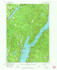
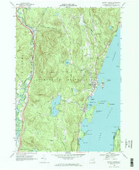
The eastern shores of Lake George define this landscape, where the resort community of Bolton Landing serves as a gateway to the numerous islands and bays of the Adirondacks. The map details the varied shoreline from Northwest Bay down to Huddle Bay, including major landforms like Crown Island, Dome Island, and Green Island. Inland, the terrain rises sharply toward Cat Mountain and Pole Hill, with numerous small watercourses like Indian Brook and Finkle Brook cutting through the highlands.
Find a feature on this map
121 named features on this map. Tap any name to fly to it.
Don’t see what you’re looking for? This feature index may not catch every label — zoom into the map to look around manually.
Map Details
Editions of this 2023 Bolton Landing Map
This is the sole edition of this map. No revisions or reprints were ever made.
Historical Maps of Pilot Knob Through Time
3 maps found