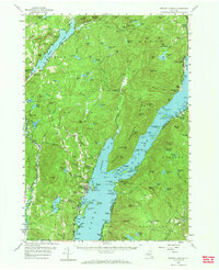
1958 Map of Bolton Landing
USGS Topo · Published 1969About this map
Lake George dominates this mid-century landscape within the Adirondack State Park, where the rugged topography of the Lake George Range and the Tongue Mountain Range meets the water's edge. The settlement at Bolton Landing serves as a focal point, supported by smaller lakeside hamlets like Silver Bay, Hague, and Huletts Landing on the eastern shore. Away from the main lake, the map reveals a network of interior water bodies such as Brant Lake, Trout Lake, and Sherman Lake, indicating a region defined by its reliance on water-based access and recreation. Local history is evident in landmarks like the Union Chapel near Sabbath Day Point and various cemeteries scattered throughout the township of Bolton. The complex terrain of peaks including Black Mtn, Sleeping Beauty, and Cat Mtn illustrates the limited arable land, which likely shaped the area's development into a major Adirondack destination.
Find a feature on this map
92 named features on this map. Tap any name to fly to it.
Don’t see what you’re looking for? This feature index may not catch every label — zoom into the map to look around manually.
Map Details
Editions of this 1958 Bolton Landing Map
4 editions found
Other maps of this area

1893 · Fort Ann
USGS Topo · 1:62,500

1893 · Whitehall
USGS Topo · 1:62,500

1894 · Ticonderoga
USGS Topo · 1:62,500

1895 · Whitehall
USGS Topo · 1:62,500

1895 · North Creek
USGS Topo · 1:62,500

1895 · Fort Ann
USGS Topo · 1:62,500

1895 · Paradox Lake
USGS Topo · 1:62,500

1895 · Glens Falls
USGS Topo · 1:62,500

1896 · Ticonderoga
USGS Topo · 1:62,500

1897 · Bolton
USGS Topo · 1:62,500