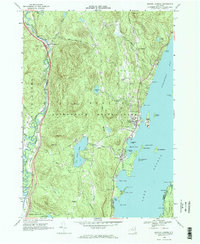
1966 Map of Bolton Landing
USGS Topo · Published 1969About this map
Lake George and the Schroon River define the eastern and western boundaries of this mid-1960s study within the Adirondack State Park. The shoreline of Northwest Bay is a focal point, featuring prominent landforms like Montcalm Point, Braley Point, and the numerous islands of the Huddle Bay area, including Dome Island and Green Island. The map records a landscape where recreation and quiet settlements overlap, from the Golf Course near Federal Hill to the cluster of homes and services at Bolton Landing. Interior heights such as Cat Mountain and Lamb Hill rise above valley water bodies like Trout Lake and Edgecomb Pond, which serves as a critical local reservoir. Genealogists will find interest in the scattered burial sites, including New Vermont Cem, Federal Hill Cem, and Lamb Hill Cem, documenting the area's older highland communities.
Find a feature on this map
64 named features on this map. Tap any name to fly to it.
Don’t see what you’re looking for? This feature index may not catch every label — zoom into the map to look around manually.
Map Details
Editions of this 1966 Bolton Landing Map
2 editions found
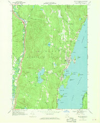
Other maps of this area

1895 · North Creek
USGS Topo · 1:62,500

1895 · Glens Falls
USGS Topo · 1:62,500

1897 · Bolton
USGS Topo · 1:62,500

1897 · Glens Falls
USGS Topo · 1:62,500

1897 · North Creek
USGS Topo · 1:62,500

1900 · Bolton
USGS Topo · 1:62,500

1903 · Luzerne
USGS Topo · 1:62,500

1938 · Glens Falls
USGS Topo · 1:62,500

1947 · Glens Falls
USGS Topo · 1:62,500

1950 · Glens Falls
USGS Topo · 1:250,000