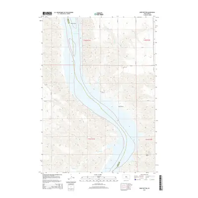
2015 Map of Bond Bottom
USGS Topo · Published 2015About this map
The Missouri River carves a broad valley through the center of this landscape, separating the border of Lyman and Brule Counties. In this stretch of South Dakota, the river feeds into Lake Francis Case, where the waters widen around Bailey Island and the bottomlands of Bond Bottom. The terrain is defined by steep draws and drainage networks formed by Fivemile Creek, Smith Creek, and Elm Creek. To the southeast, the prominent elevation of Twin Butte stands out against the surrounding breaks. This 2015 survey shows a rural environment primarily organized by a grid of section lines and gravel roads, such as Elm Creek Road and 344th Ave, illustrating how the modern road network navigates the complex topography of the river bluffs.
Find a feature on this map
23 named features on this map. Tap any name to fly to it.
Don’t see what you’re looking for? This feature index may not catch every label — zoom into the map to look around manually.
Map Details
Editions of this 2015 Bond Bottom Map
This is the sole edition of this map. No revisions or reprints were ever made.
Other maps of this area

1940 · Iona
USGS Topo · 1:62,500

1944 · Iona
USGS Topo · 1:62,500

1952 · Iona NW
USGS Topo · 1:24,000

1955 · Mitchell
USGS Topo · 1:250,000

1959 · Mitchell
USGS Topo · 1:250,000

1971 · Lucas NW
USGS Topo · 1:24,000

1971 · Dixon
USGS Topo · 1:24,000

1971 · Dixon NE
USGS Topo · 1:24,000
1974 · Bond Bottom
USGS Topo · 1:24,000

1974 · Red Lake West
USGS Topo · 1:24,000