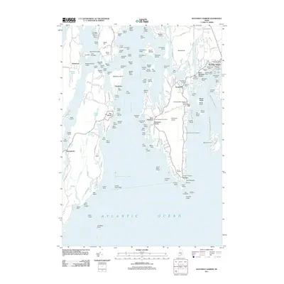
2011 Map of Boothbay Harbor
USGS Topo · Published 2011About this map
Boothbay Harbor serves as the focal point of this coastal survey, where the working waterfront meets the deep traditions of maritime Maine. The map details a complex shoreline defined by Sheepscot Bay and the Sheepscot River, showing the village centers of Southport, West Harbor, and Newagen. Beyond the harbors, the landscape is punctuated by numerous named islands and ledges, such as Isle of Springs and Indiantown Island, illustrating the navigational challenges of these waters. For those tracing local families, the presence of the Wiley Cemetery and Wilson Cemetery, along with landmarks like Robinson Wharf and the Cuckolds Lighthouse, provides a clear view of the area's established community and heritage. The distribution of small settlements like Five Islands and Robinhood underscores the region's enduring character as a network of interconnected coastal hamlets.
Find a feature on this map
169 named features on this map. Tap any name to fly to it.
Don’t see what you’re looking for? This feature index may not catch every label — zoom into the map to look around manually.
Map Details
Editions of this 2011 Boothbay Harbor Map
This is the sole edition of this map. No revisions or reprints were ever made.
Other maps of this area

1893 · Small Point
USGS Topo · 1:62,500

1893 · Boothbay
USGS Topo · 1:62,500

1894 · Bath
USGS Topo · 1:62,500

1919 · Small Point
USGS Topo · 1:62,500

1920 · Bath
USGS Topo · 1:62,500

1941 · Boothbay
USGS Topo · 1:62,500

1943 · Boothbay
USGS Topo · 1:62,500

1944 · Boothbay
USGS Topo · 1:62,500

1944 · Small Point
USGS Topo · 1:62,500

1945 · Bath
USGS Topo · 1:62,500