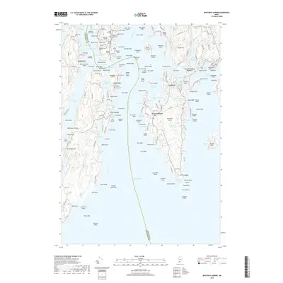
2018 Map of Boothbay Harbor
USGS Topo · Published 2018About this map
West Boothbay Harbor and the surrounding islands of the Sheepscot River estuary define this coastal landscape, where the seafaring history of Lincoln Co and Sagadahoc Co meets the modern shoreline. The intricate network of tidal waters includes Ebenecook Harbor, Five Islands Harbor, and Robinhood Cove, which separate the rugged landmasses of Georgetown Island and Westport Island. For genealogists, the map is remarkably detailed with family-named burial grounds, such as the Stephen Jewett Cem, Nelson Blake Cem, and the Harriman Mitchell Stacy Cem. These small cemeteries are found throughout the region, from the northern tip of Westport Island down to the southern reaches of Newagen. The maritime character of the area is further evidenced by landmarks like the Hendricks Head lighthouse and the numerous ledges and islands, including MacMahan Island and the Cuckolds, which have shaped local navigation for generations.
Find a feature on this map
210 named features on this map. Tap any name to fly to it.
Don’t see what you’re looking for? This feature index may not catch every label — zoom into the map to look around manually.
Map Details
Editions of this 2018 Boothbay Harbor Map
This is the sole edition of this map. No revisions or reprints were ever made.
Other maps of this area

1893 · Small Point
USGS Topo · 1:62,500

1893 · Boothbay
USGS Topo · 1:62,500

1894 · Bath
USGS Topo · 1:62,500

1919 · Small Point
USGS Topo · 1:62,500

1920 · Bath
USGS Topo · 1:62,500

1941 · Boothbay
USGS Topo · 1:62,500

1943 · Boothbay
USGS Topo · 1:62,500

1944 · Boothbay
USGS Topo · 1:62,500

1944 · Small Point
USGS Topo · 1:62,500

1945 · Bath
USGS Topo · 1:62,500