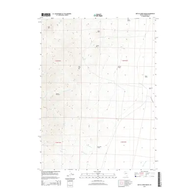
2015 Map of Bottle Creek Ranch
USGS Topo · Published 2015About this map
Bottle Creek Ranch anchors the eastern edge of the Jackson Mountains in this high-desert landscape of Humboldt County. The terrain transitions sharply from the high peaks of Buff Peak and Halburg Mtn down into the expansive Desert Valley. This area is defined by its seasonal hydrology, where drainages like Bottle Cr and the Little S Fork Bottle Cr flow toward the lower basin, eventually reaching the Bottle Cr Slough.
Find a feature on this map
24 named features on this map. Tap any name to fly to it.
Don’t see what you’re looking for? This feature index may not catch every label — zoom into the map to look around manually.
Map Details
Editions of this 2015 Bottle Creek Ranch Map
This is the sole edition of this map. No revisions or reprints were ever made.
Other maps of this area

1886 · Disaster
USGS Topo · 1:250,000

1893 · Disaster
USGS Topo · 1:250,000

1954 · Vya
USGS Topo · 1:250,000

1958 · Vya
USGS Topo · 1:250,000

1961 · Bottle Creek
USGS Topo · 1:62,500

1962 · Vya
USGS Topo · 1:250,000

1966 · Donna Schee Peak
USGS Topo · 1:62,500
1982 · Bottle Creek Slough SW
USGS Topo · 1:24,000
1982 · Presnel Well
USGS Topo · 1:24,000
1982 · Bottle Creek Slough NW
USGS Topo · 1:24,000