
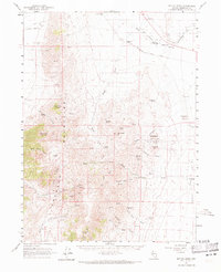
1961 Map of Bottle Creek
USGS Topo · Published 1963About this map
Mining operations and ranching outposts define this high-desert landscape in northern Nevada during the early 1960s. The Jackson Mountains dominate the western portion of the map, rising to heights at Parrot Peak and Deer Creek Peak. Along the eastern slopes and within the deep cuts of Halburg Canyon, a concentration of mercury and cinnabar mining activity is visible at sites like the Niebuhr Mine, White Peaks Mine, and the Baldwin Mine.
Find a feature on this map
49 named features on this map. Tap any name to fly to it.
Don’t see what you’re looking for? This feature index may not catch every label — zoom into the map to look around manually.
Map Details
Editions of this 1961 Bottle Creek Map
2 editions found
Other maps of this area

1886 · Disaster
USGS Topo · 1:250,000

1893 · Disaster
USGS Topo · 1:250,000

1954 · Vya
USGS Topo · 1:250,000

1958 · Vya
USGS Topo · 1:250,000

1961 · Quinn River Crossing
USGS Topo · 1:62,500

1961 · Thacker Pass
USGS Topo · 1:62,500

1962 · Vya
USGS Topo · 1:250,000

1965 · Duffer Peak
USGS Topo · 1:62,500

1966 · Donna Schee Peak
USGS Topo · 1:62,500

1966 · King Lear Peak
USGS Topo · 1:62,500