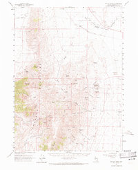
1961 Map of Bottle Creek
USGS Topo · Published 1971About this map
Mining claims and isolated ranches define this 1960s landscape in the high desert of Humboldt County. The eastern slopes of the Jackson Mountains are dotted with mid-century mineral extraction sites, including the White Peaks Mine, Red Ore Mine, and the McAdoo Mine situated near Halburg Mtn. These operations represent the persistent search for mercury and other ores in the Great Basin. To the northeast, the Quinn River flows past a portion of the Fort Mc Dermitt Indian Reservation, where the Old Denio Road provides a primary transit link across the sagebrush flats.
Find a feature on this map
46 named features on this map. Tap any name to fly to it.
Don’t see what you’re looking for? This feature index may not catch every label — zoom into the map to look around manually.
Map Details
Editions of this 1961 Bottle Creek Map
2 editions found
Other maps of this area

1886 · Disaster
USGS Topo · 1:250,000

1893 · Disaster
USGS Topo · 1:250,000

1954 · Vya
USGS Topo · 1:250,000

1958 · Vya
USGS Topo · 1:250,000

1961 · Quinn River Crossing
USGS Topo · 1:62,500

1961 · Thacker Pass
USGS Topo · 1:62,500

1961 · Bottle Creek
USGS Topo · 1:62,500

1962 · Vya
USGS Topo · 1:250,000

1965 · Duffer Peak
USGS Topo · 1:62,500

1966 · Donna Schee Peak
USGS Topo · 1:62,500