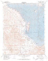
1970 Map of Boulder Beach
USGS Topo · Published 1973About this map
The Lake Mead shoreline near the Nevada-Arizona border reveals a complex infrastructure of water management and mid-century recreation. Dominated by the Boulder Basin, the landscape is marked by the Alfred Merritt Smith Water Treatment Plant and a series of pumping stations and aqueducts that facilitate water transport through the River Mountains Tunnel. Along the coast, the Lake Mead Marina and Lake Mead Lodge serve as hubs for visitors to the Lake Mead National Recreation Area, while an Old Railroad Grade traces the historic path used during the construction era of nearby dams. This map specifically documents the developed waterfront at Boulder Beach, showing the spatial arrangement of the Trailer Park, an Outdoor Theater, and the Visitor Center before late-century shoreline changes altered the geography of Hemenway Harbor.
Find a feature on this map
43 named features on this map. Tap any name to fly to it.
Don’t see what you’re looking for? This feature index may not catch every label — zoom into the map to look around manually.
Map Details
Editions of this 1970 Boulder Beach Map
2 editions found
Other maps of this area

1886 · Camp Mohave
USGS Topo · 1:250,000

1886 · Saint Thomas
USGS Topo · 1:250,000

1892 · Camp Mohave
USGS Topo · 1:250,000

1893 · Saint Thomas
USGS Topo · 1:250,000

1926 · Nelson
USGS Topo · 1:96,000

1926 · Boulder Canyon
USGS Topo · 1:96,000

1942 · Camp Mohave
USGS Topo · 1:250,000

1947 · Kingman
USGS Topo · 1:250,000

1948 · Kingman
USGS Topo · 1:250,000

1952 · Henderson
USGS Topo · 1:62,500