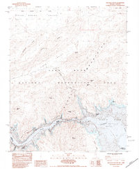
1983 Map of Boulder Canyon
USGS Topo · Published 1984About this map
Lake Mead and the Colorado River dominate this desert landscape, where the waters of the impounded river wind through the dramatic topography of Boulder Canyon. Surveyed in the early 1980s, the map documents the complex shoreline of the Lake Mead National Recreation Area, highlighting numerous named inlets such as Wishing Well Cove, Gordys Cove, and Canyon Cove. The terrain is defined by prominent ridges and peaks, including the Black Mountains, Arch Mountain, and Razorback Ridge, which separate the expansive Bitter Spring Valley from Pinto Valley. The geological transition at The Narrows and the broad expanse of the Virgin Basin provide a detailed look at the hydrology of the region as it appeared before modern shoreline shifts. Notable landmarks like Sandstone Spring and Little Gyp Beds offer specific points of interest for those studying the natural history of this Nevada-Arizona borderland.
Find a feature on this map
34 named features on this map. Tap any name to fly to it.
Don’t see what you’re looking for? This feature index may not catch every label — zoom into the map to look around manually.
Map Details
Editions of this 1983 Boulder Canyon Map
This is the sole edition of this map. No revisions or reprints were ever made.
Other maps of this area

1886 · Saint Thomas
USGS Topo · 1:250,000

1893 · Saint Thomas
USGS Topo · 1:250,000

1926 · Bonelli
USGS Topo · 1:96,000

1926 · Boulder Canyon
USGS Topo · 1:96,000

1953 · Muddy Peak
USGS Topo · 1:62,500

1953 · Overton Beach
USGS Topo · 1:62,500

1953 · Hoover Dam
USGS Topo · 1:62,500

1953 · Virgin Basin
USGS Topo · 1:62,500

1954 · Las Vegas
USGS Topo · 1:250,000

1957 · Las Vegas
USGS Topo · 1:250,000