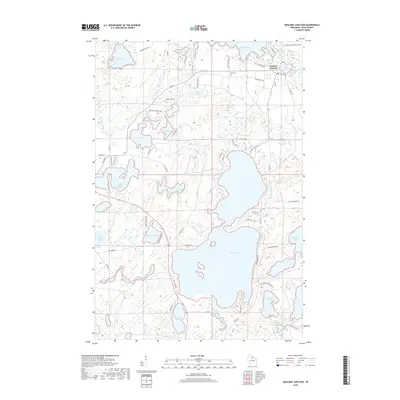
2018 Map of Boulder Junction
USGS Topo · Published 2018About this map
Trout Lake dominates the central landscape of this Vilas County quadrangle, serving as a hub for the intricate network of water bodies and streams that define the region. In the northeastern corner, the settlement of Boulder Junction sits at the intersection of Co HWY M and Co RD K, near the banks of Boulder Lake. This area is characterized by an exceptionally high density of glacial lakes, including Upper Gresham Lake, Allequash Lake, and the smaller Little Rice Lake, all linked by waterways like the Manitowish River. Land use in the vicinity is reflected in the distribution of family and local roads such as Whitney Lake RD and N Creek RD, alongside the Pines Cem near the northern shore of Nichols Lake. The mapping reveals a shoreline economy and lifestyle where names like Cathedral Pt Rd and Camp Manitowish Ln point toward established community landmarks and gathering places.
Find a feature on this map
66 named features on this map. Tap any name to fly to it.
Don’t see what you’re looking for? This feature index may not catch every label — zoom into the map to look around manually.
Map Details
Editions of this 2018 Boulder Junction Map
This is the sole edition of this map. No revisions or reprints were ever made.
Other maps of this area

1938 · Minocqua
USGS Topo · 1:48,000

1938 · Lac Du Flambeau
USGS Topo · 1:48,000

1939 · Trout Lake
USGS Topo · 1:48,000

1939 · Lac Du Flambeau
USGS Topo · 1:48,000

1939 · Winchester
USGS Topo · 1:48,000

1946 · Winchester
USGS Topo · 1:48,000

1946 · Minocqua
USGS Topo · 1:48,000

1946 · Lac Du Flambeau
USGS Topo · 1:48,000

1946 · Trout Lake
USGS Topo · 1:48,000

1949 · Trout Lake
USGS Topo · 1:48,000