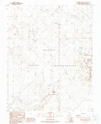
1989 Map of Boundary Butte
USGS Topo · Published 1989About this map
The high desert landscape of the Navajo Indian Reservation in San Juan County is defined by its arid geography and subterranean resources. Centered on the prominent landmark of Boundary Butte, the terrain transitions from the high elevations of Boundary Butte Mesa down toward the sweeping expanse of the Nokaito Bench. Water is the critical scarcity here, marked by scattered essential sources such as Sand Spring, Little Water, and Salt Spring.
Find a feature on this map
17 named features on this map. Tap any name to fly to it.
Don’t see what you’re looking for? This feature index may not catch every label — zoom into the map to look around manually.
Map Details
Editions of this 1989 Boundary Butte Map
This is the sole edition of this map. No revisions or reprints were ever made.
Other maps of this area

1886 · Abajo
USGS Topo · 1:250,000

1892 · Abajo
USGS Topo · 1:250,000

1892 · Canyon De Chelly
USGS Topo · 1:250,000

1893 · Abajo
USGS Topo · 1:250,000

1953 · Dinne Mesa NW
USGS Topo · 1:24,000

1953 · Toh-Atin Mesa
USGS Topo · 1:62,500

1954 · Shiprock
USGS Topo · 1:250,000

1956 · Cortez
USGS Topo · 1:250,000

1958 · Cortez
USGS Topo · 1:250,000

1958 · Shiprock
USGS Topo · 1:250,000