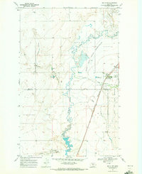
1969 Map of Box Elder
USGS Topo · Published 1972About this map
Box Elder serves as the primary hub on this late 1960s survey, situated where the Burlington Northern railroad corridor meets the eastern boundary of the Rocky Boys Indian Reservation. The landscape is defined by the winding course of Big Sandy Creek, which creates a riparian thread through the surrounding terrain of coulees and reservoirs. Small-scale water management is evident in the presence of Schmidt Res and Grass Res, while the lower portion of the sheet features the expanse of Lonesome Lake.
Find a feature on this map
19 named features on this map. Tap any name to fly to it.
Don’t see what you’re looking for? This feature index may not catch every label — zoom into the map to look around manually.
Map Details
Editions of this 1969 Box Elder Map
This is the sole edition of this map. No revisions or reprints were ever made.
Other maps of this area

1904 · Boxelder
USGS Topo · 1:62,500

1906 · Boxelder
USGS Topo · 1:62,500

1919 · Big Sandy
USGS Topo · 1:125,000

1953 · Havre
USGS Topo · 1:250,000

1954 · Shelby
USGS Topo · 1:250,000

1957 · Havre
USGS Topo · 1:250,000

1958 · Shelby
USGS Topo · 1:250,000

1958 · Havre
USGS Topo · 1:250,000

1959 · Laredo
USGS Topo · 1:62,500

1959 · Centennial Mountain
USGS Topo · 1:62,500