
Historical Maps of Montana
What stories do these 6,572 old maps tell about Montana's past? From 1885 to present day, these maps reveal the evolution of streets, neighborhoods, iconic landmarks, and natural features in stunning high-res detail. Whether you're a history enthusiast, genealogist, or professional in education, environmental work, or architecture, these maps are perfect for exploration, research, and discovery.
Discover Montana's history through maps:
- Trace Montana's growth: Explore earlier and latest maps and editions to uncover how the region changed over time.
- Examine technical details: Each map includes its creators, publishers, scale, dimensions, and full source information.
- Layer maps with modern tools & imagery: Compare historical maps to modern-day with high-resolution satellite imagery and detailed LiDAR layers.
- Sourced from trusted archives: Carefully preserved and digitized by institutions like the United Stated Geological Survey and the US Library of Congress.
- Access in any format: View and explore in high resolution, download for offline use, or order a museum-quality print for yourself or a loved one.
Begin your journey into Montana's history with these remarkable must-see maps.
Montana maps
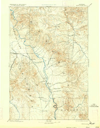
(6,572)- 1885 Map of Gallatin
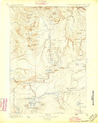 1885 Gallatin1885 Print · USGSCovers Montana, including Mammoth, Park County, and other nearby areas
 - 1885 Map of Gallatin, 1886 Print
 1885 Gallatin1886 Print · USGSCovers Montana, including Mammoth, Park County, and other nearby areas
 - 1885 Map of Gallatin, 1895 Print
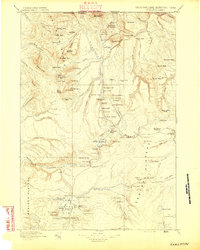 1885 Gallatin1895 Print · USGSCovers Montana, including Mammoth, Park County, and other nearby areas
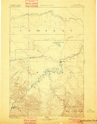
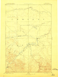
 - 1886 Map of Great Falls
 1886 Great Falls1886 Print · USGSCovers Montana, including Great Falls, Cascade, and other nearby areas
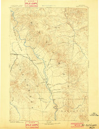
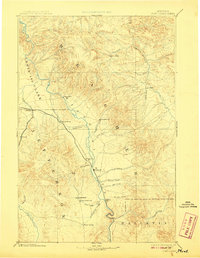
 - 1886 Map of Fort Logan
 1886 Fort Logan1886 Print · USGSCovers Montana, including Helena, Montana City, and other nearby areas
 - 1886 Map of Canyon
 1886 Canyon1886 Print · USGSCovers Montana, including Buffalo Ford, Tower Junction, and other nearby areas
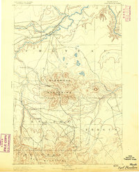
 - 1886 Map of Little Belt Mts.
 1886 Little Belt Mts.1886 Print · USGSCovers Montana, including White Sulphur Springs, Neihart, and other nearby areas
 - 1886 Map of Fort Logan, 1896 Print
 1886 Fort Logan1896 Print · USGSCovers Montana, including Helena, Montana City, and other nearby areas
 - 1886 Map of Great Falls, 1896 Print
 1886 Great Falls1896 Print · USGSCovers Montana, including Great Falls, Cascade, and other nearby areas
 - 1886 Map of Fort Logan, 1901 Print
 1886 Fort Logan1901 Print · USGSCovers Montana, including Helena, Montana City, and other nearby areas
 - 1886 Map of Great Falls, 1901 Print
 1886 Great Falls1901 Print · USGSCovers Montana, including Great Falls, Cascade, and other nearby areas
 - 1886 Map of Fort Logan, 1908 Print
 1886 Fort Logan1908 Print · USGSCovers Montana, including Helena, Montana City, and other nearby areas
 - 1886 Map of Great Falls, 1912 Print
 1886 Great Falls1912 Print · USGSCovers Montana, including Great Falls, Cascade, and other nearby areas
 - 1886 Map of Fort Logan, 1914 Print
 1886 Fort Logan1914 Print · USGSCovers Montana, including Helena, Montana City, and other nearby areas
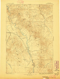
 - 1888 Map of Three Forks
 1888 Three Forks1888 Print · USGSCovers Montana, including Bozeman, Belgrade, and other nearby areas
 - 1889 Map of Big Snowy Mountain
 1889 Big Snowy Mountain1889 Print · USGSCovers Montana, including Harlowton, Ryegate, and other nearby areas
 - 1889 Map of Helena
 1889 Helena1889 Print · USGSCovers Montana, including Butte, Helena, and other nearby areas
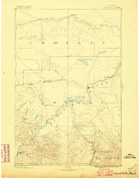
 - 1890 Map of Fort Benton
 1890 Fort Benton1890 Print · USGSCovers Montana, including Fort Benton, Belt, and other nearby areas
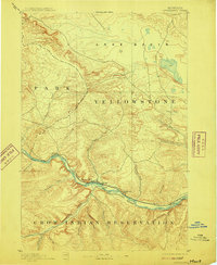
 - 1891 Map of Livingston
 1891 Livingston1891 Print · USGSCovers Montana, including Bozeman, Livingston, and other nearby areas
 - 1891 Map of Big Timber
 1891 Big Timber1891 Print · USGSCovers Montana, including Big Timber, Reed Point, and other nearby areas
 - 1892 Map of Fort Benton
 1892 Fort Benton1892 Print · USGSCovers Montana, including Fort Benton, Belt, and other nearby areas
 - 1892 Map of Stillwater
 1892 Stillwater1892 Print · USGSCovers Montana, including Columbus, Absarokee, and other nearby areas
 - 1892 Map of Fort Benton
 1892 Fort Benton1892 Print · USGSCovers Montana, including Fort Benton, Belt, and other nearby areas
 - 1892 Map of Stillwater, 1898 Print
 1892 Stillwater1898 Print · USGSCovers Montana, including Columbus, Absarokee, and other nearby areas
 - 1892 Map of Stillwater, 1910 Print
 1892 Stillwater1910 Print · USGSCovers Montana, including Columbus, Absarokee, and other nearby areas
Showing maps 1-25 of 6,572
Top cities in Montana
- Billings historical maps
- Missoula historical maps
- Great Falls historical maps
- Bozeman historical maps
- Butte historical maps
- Helena historical maps
See more
Top counties in Montana
- Yellowstone County historical maps
- Missoula County historical maps
- Gallatin County historical maps
- Flathead County historical maps
- Cascade County historical maps
- Lewis and Clark County historical maps
See more
Frequently asked questions
- What are the different types of historical maps available for Montana?
- What is the oldest map of Montana?
- Where can I purchase historical maps of Montana for my home or office?
- Where can I download high-res historical maps of Montana?
- Are there historical topographic maps available for Montana?
- Is there historical aerial imagery available for Montana?
- Where are historical maps of Montana sourced from?