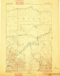
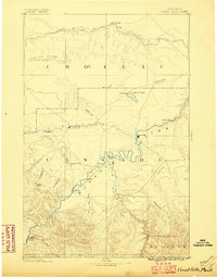
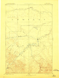
1886 Map of Great Falls
USGS Topo · Published 1901About this map
The confluence of the Sun River and the Missouri River anchors this late nineteenth-century reconnaissance of central Montana, a landscape defined by its vital watercourses and early territorial outposts. Established military and religious sites, such as Fort Shaw and St. Peter's Mission, highlight the strategic and cultural importance of the region during this era. The map traces the winding paths of the Teton River to the north and the Smith River to the south, revealing a network of early settlements including Perrysburgh, Ulida, and Truly. The topography is marked by distinctive features like Teton Ridge and the Alkali Pond, reflecting the transition from river valleys to high plains. This survey captures the region just as the city of Great Falls was beginning its ascent, documenting the foundational geography of Cascade, Choteau, and Meagher counties before the arrival of extensive rail networks and industrial development.
Find a feature on this map
32 named features on this map. Tap any name to fly to it.
Don’t see what you’re looking for? This feature index may not catch every label — zoom into the map to look around manually.
Map Details
Editions of this 1886 Great Falls Map
4 editions found
Other maps of this area

1886 · Great Falls
USGS Topo · 1:250,000

1886 · Fort Logan
USGS Topo · 1:250,000

1886 · Little Belt Mts.
USGS Topo · 1:250,000

1889 · Helena
USGS Topo · 1:250,000

1890 · Fort Benton
USGS Topo · 1:250,000

1892 · Fort Benton
USGS Topo · 1:250,000

1893 · Helena
USGS Topo · 1:250,000

1894 · Little Belt Mts.
USGS Topo · 1:250,000

1897 · Fort Benton
USGS Topo · 1:250,000

1897 · Little Belt Mts.
USGS Topo · 1:250,000