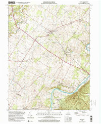
1999 Map of Boyce
USGS Topo · Published 2001About this map
Blandy Experimental Farm (Univ of Virginia) and the historic Carter Hall estate anchor this landscape near Boyce, where the valley transitions toward the winding Shenandoah River. The map reveals a high concentration of established cultural landmarks, including Old Chapel and Little Chapel near Briggs, alongside the Powhatan Sch and Millwood Country Club. This 1999 revision of 1960s topography highlights how the region's agricultural and estate heritage remained intact through the late 20th century.
Find a feature on this map
50 named features on this map. Tap any name to fly to it.
Don’t see what you’re looking for? This feature index may not catch every label — zoom into the map to look around manually.
Map Details
Editions of this 1999 Boyce Map
This is the sole edition of this map. No revisions or reprints were ever made.
Other maps of this area

1884 · Harpers Ferry
USGS Topo · 1:125,000

1891 · Harpers Ferry
USGS Topo · 1:125,000

1893 · Luray
USGS Topo · 1:125,000

1893 · Harpers Ferry
USGS Topo · 1:125,000

1894 · Warrenton
USGS Topo · 1:125,000

1894 · Winchester
USGS Topo · 1:125,000

1905 · Luray
USGS Topo · 1:125,000

1916 · Berryville
USGS Topo · 1:62,500

1938 · Winchester
USGS Topo · 1:48,000

1939 · Front Royal
USGS Topo · 1:48,000