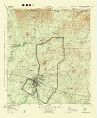
1944 Map of Brackettville
USGS Topo · Published 1944About this map
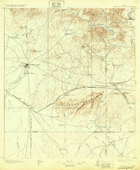
Brackettville serves as the focal point of this mid-century survey, positioned at the edge of the expansive Fort Clark military reservation. The importance of water in this semi-arid Kinney County landscape is evident, with the historic Las Moras Spring feeding the drainage near the town center. The map captures a transition from traditional livestock ranching to military infrastructure, featuring an Airfield and the complex Fort Clark Reservation Boundary that divides the town from the fort's training grounds. Numerous family-owned holdings like the Nolan-Postell Ranch, W G Lackey Ranch, and Shehan Ranch are scattered across the precincts, often centered on vital water sources like Pinto Creek or isolated landmarks such as Nine Mile Well and Ten Mile Tank. The northern terrain is defined by the Nueces River and various peaks, including Pinto Mt and Las Moras Mt.
Find a feature on this map
50 named features on this map. Tap any name to fly to it.
Don’t see what you’re looking for? This feature index may not catch every label — zoom into the map to look around manually.
Map Details
Editions of this 1944 Brackettville Map
This is the sole edition of this map. No revisions or reprints were ever made.
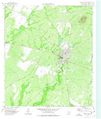
Historical Maps of Brackettville Through Time
8 maps found