
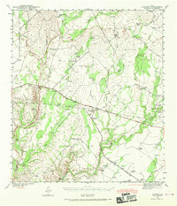
1941 Map of Standart
USGS Topo · Published 1965About this map
Standart and the surrounding ranchlands of Kinney County appear here as surveyed in the early 1940s, revealing a landscape defined by seasonal watercourses and private pastoral holdings. The Southern Pacific railroad cuts a diagonal line across the terrain, serving small stations and sidings like Amanda and Pinto. This transit corridor parallels the Jefferson Memorial Highway, providing the primary link between these isolated livestock operations and the larger regional markets.
Find a feature on this map
38 named features on this map. Tap any name to fly to it.
Don’t see what you’re looking for? This feature index may not catch every label — zoom into the map to look around manually.
Map Details
Editions of this 1941 Standart Map
2 editions found
Other maps of this area

1893 · Nueces
USGS Topo · 1:125,000

1896 · Nueces
USGS Topo · 1:125,000

1896 · Brackett
USGS Topo · 1:125,000

1897 · Brackett
USGS Topo · 1:125,000

1941 · Tequesquite Creek
USGS Topo · 1:62,500

1943 · Standart
USGS Topo · 1:62,500

1943 · Del Rio
USGS Topo · 1:62,500

1944 · Sycamore Ranch
USGS Topo · 1:62,500

1944 · Tequesquite Creek
USGS Topo · 1:62,500

1944 · Spofford
USGS Topo · 1:62,500