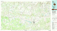
1985 Map of Brady
USGS Topo · Published 1992About this map
Brady Reservoir and the surrounding Brady Mountains anchor this mid-1980s landscape at the heart of Texas. The survey captures the regional hub of Brady as it appeared decades ago, serving as a crossroads for the Gulf Colorado and Santa Fe Railway and local travel. To the north, the Colorado River winds through a network of small farming and ranching communities such as Stacy, Waldrip, and Winchell, while the western reaches include the high ground of the Brady Mountains. This area is defined by its transition from open plateau to creek-carved lowlands, with the San Saba River cutting through the southern portion of the quadrangle. For those studying local heritage, the map documents numerous small settlements like West Sweden, Placid, and Whiteland alongside recreational landmarks like Lake Brady Park and Richards Park.
Find a feature on this map
68 named features on this map. Tap any name to fly to it.
Don’t see what you’re looking for? This feature index may not catch every label — zoom into the map to look around manually.
Map Details
Editions of this 1985 Brady Map
2 editions found
Other maps of this area

1885 · San Saba
USGS Topo · 1:125,000

1887 · Llano
USGS Topo · 1:125,000

1887 · Mason
USGS Topo · 1:125,000

1887 · Coleman
USGS Topo · 1:125,000

1889 · Brownwood
USGS Topo · 1:125,000

1889 · Coleman
USGS Topo · 1:125,000

1891 · Hayrick
USGS Topo · 1:125,000

1892 · San Angelo
USGS Topo · 1:125,000

1892 · Eden
USGS Topo · 1:125,000

1892 · Ballinger
USGS Topo · 1:125,000