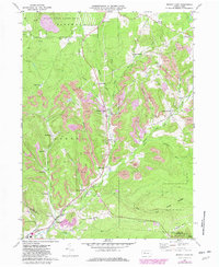
1970 Map of Brandy Camp
USGS Topo · Published 1982About this map
The industrial and rural character of Elk County is clearly defined along the Brandy Camp Creek corridor, where coal extraction and rail transport shaped the local geography. Numerous Strip Mine operations and Gas Well sites dot the hillsides of Ridgway and Horton townships, reflecting the region's reliance on natural resources. In the valley, a string of small settlements including Brandy Camp, Elbon, and Brockport grew around the transportation network.
Find a feature on this map
48 named features on this map. Tap any name to fly to it.
Don’t see what you’re looking for? This feature index may not catch every label — zoom into the map to look around manually.
Map Details
Editions of this 1970 Brandy Camp Map
3 editions found
Other maps of this area

1922 · Du Bois
USGS Topo · 1:62,500

1924 · Du Bois
USGS Topo · 1:62,500

1929 · Penfield
USGS Topo · 1:62,500

1932 · Penfield
USGS Topo · 1:62,500

1940 · Hallton
USGS Topo · 1:48,000

1941 · Ridgway
USGS Topo · 1:62,500

1943 · Hallton
USGS Topo · 1:62,500

1944 · Du Bois
USGS Topo · 1:62,500

1944 · Ridgway
USGS Topo · 1:62,500

1957 · Warren
USGS Topo · 1:250,000
Featured Places
- Drummond, Horton Township
- Snyder Township, PA
- Fox Township, PA
- Ridgway Township, PA
- Kylers Corners, Fox Township