1968 Map of Brenham
USGS Topo · Published 1970About this map
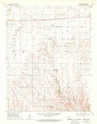
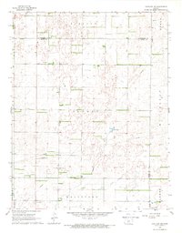
Brenham and the surrounding plains of Kiowa County are defined by a mix of agricultural surveying and industrial infrastructure during the late 1960s. The northern portion of the landscape is dominated by the Chicago Rock Island and Pacific railroad, which runs parallel to the primary east-west road. This transit corridor anchors the small settlements and rural homesteads that dot the high ground above the drainage basins of Thompson Creek and E Fk Rattlesnake Cr.
Find a feature on this map
16 named features on this map. Tap any name to fly to it.
Don’t see what you’re looking for? This feature index may not catch every label — zoom into the map to look around manually.
Map Details
Editions of this 1968 Brenham Map
This is the sole edition of this map. No revisions or reprints were ever made.
Other maps of this area

1889 · Kinsley
USGS Topo · 1:125,000

1892 · Kinsley
USGS Topo · 1:125,000

1892 · Coldwater
USGS Topo · 1:125,000

1894 · Kinsley
USGS Topo · 1:125,000

1955 · Pratt
USGS Topo · 1:250,000

1959 · Pratt
USGS Topo · 1:250,000
1968 · Haviland NW
USGS Topo · 1:24,000
1968 · Belvidere
USGS Topo · 1:24,000
1968 · Haviland
USGS Topo · 1:24,000
1968 · Haviland NE
USGS Topo · 1:24,000