
1959 Map of Pratt
USGS Topo · Published 1959About this map
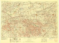
The Arkansas River curves through this mid-century landscape of south-central Kansas, illustrating the dense network of grain elevators and rail sidings that defined the region's economy in the 1950s. Highlighting the intersection of major transit routes, the map shows the Atchison Topeka and Santa Fe and Chicago Rock Island and Pacific railroads connecting rural hubs like Pratt and Kinsley. Local social centers such as the Blue Ridge Community House and Prairie Oak School appear alongside essential water sources including Rattlesnake Creek and the Medicine Lodge River. This survey captures the transition of the High Plains into a highly organized agricultural grid, evidenced by the presence of the KSC Exp Farm and established county seats, while southern areas near the Oklahoma border show the rugged drainage of Bear Creek and Cavalry Creek.
Find a feature on this map
129 named features on this map. Tap any name to fly to it.
Don’t see what you’re looking for? This feature index may not catch every label — zoom into the map to look around manually.
Map Details
Editions of this 1959 Pratt Map
2 editions found
Other maps of this area

1889 · Anthony
USGS Topo · 1:125,000

1889 · Cheney
USGS Topo · 1:125,000

1889 · Larned
USGS Topo · 1:125,000

1889 · Caldwell
USGS Topo · 1:125,000

1889 · Kinsley
USGS Topo · 1:125,000

1891 · Great Bend
USGS Topo · 1:125,000

1891 · Medicine Lodge
USGS Topo · 1:125,000

1891 · Larned
USGS Topo · 1:125,000

1891 · Hutchinson
USGS Topo · 1:125,000

1891 · Cheney
USGS Topo · 1:125,000