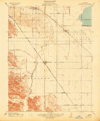
1914 Map of Brentwood
USGS Topo · Published 1914About this map
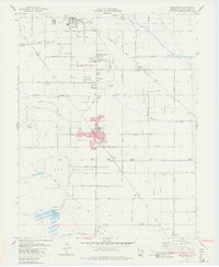
Brentwood stands at the center of this 1911 survey, a town defined by its strategic position along the Southern Pacific RR. This rail corridor cuts a sharp diagonal through the agricultural landscape, crossing paths with the San Francisco and New Orleans Line at an Oil Pumping Station to the southeast. To the north, the Atchison Topeka and Santa Fe RR serves the growing settlements of Oakley and Knightsen, illustrating a region transitioning into a high-density orchard and farming hub.
Find a feature on this map
21 named features on this map. Tap any name to fly to it.
Don’t see what you’re looking for? This feature index may not catch every label — zoom into the map to look around manually.
Map Details
Editions of this 1914 Brentwood Map
This is the sole edition of this map. No revisions or reprints were ever made.
Historical Maps of Antioch Through Time
7 maps found