1895 Map of Briceville
USGS Topo · Published 1895About this map
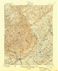
The sharp contrast between the mountain-and-valley terrain and the burgeoning coal economy of East Tennessee is documented in this 1895 survey. Major topography such as Cumberland Mountain and Walden Ridge dictates the layout of the land, while the Southern R. R. and the Knoxville and Ohio R. R. provide the vital industrial links between the interior and the outside world. Centered on the community of Briceville, the map captures a network of small settlements and mining towns including Coal Creek and Montgomery.
Find a feature on this map
125 named features on this map. Tap any name to fly to it.
Don’t see what you’re looking for? This feature index may not catch every label — zoom into the map to look around manually.
Map Details
Editions of this 1895 Briceville Map
This is the sole edition of this map. No revisions or reprints were ever made.
Historical Maps of Broadacres Through Time
3 maps found