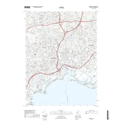
2018 Map of Bridgeport
USGS Topo · Published 2018About this map
Bridgeport is shown as a dense coastal hub, anchored by its maritime identity and industrial history along the Pequonnock River. The landscape is a network of historic hill settlements, including Meetinghouse Hill, Toilsome Hill, and Mill Hill, which overlook a complex shoreline of inlets and points. Significant genealogical and local history markers are found in burial sites like the Old Stratfield Cem and Old Burying Ground, which provide deep ties to the colonial foundations of the region. The map details the modern development of educational institutions such as Sacred Heart Univ and the Univ of Bridgeport, alongside the massive footprint of the Igor I Sikorsky Memorial Airport in Stratford. The Bridgeport - Port Jefferson Ferry route and the deep Yellow Mill Channel highlight the ongoing importance of the harbor. Public spaces like Fairchild Memorial Park and Seaside Beach are set against a backdrop of industrial infrastructure, such as Steel Point, reflecting the city's evolution from a manufacturing center to a multi-faceted urban landscape.
Find a feature on this map
100 named features on this map. Tap any name to fly to it.
Don’t see what you’re looking for? This feature index may not catch every label — zoom into the map to look around manually.
Map Details
Editions of this 2018 Bridgeport Map
This is the sole edition of this map. No revisions or reprints were ever made.
Other maps of this area

1889 · Derby
USGS Topo · 1:62,500

1891 · Bridgeport
USGS Topo · 1:62,500

1891 · Derby
USGS Topo · 1:62,500

1892 · Danbury
USGS Topo · 1:62,500

1892 · Norwalk
USGS Topo · 1:62,500

1893 · Bridgeport
USGS Topo · 1:62,500

1893 · Norwalk
USGS Topo · 1:62,500

1893 · Derby
USGS Topo · 1:62,500

1915 · Danbury
USGS Topo · 1:62,500

1920 · Bridgeport
USGS Topo · 1:62,500