
1891 Map of Bridgeport
USGS Topo · Published 1891About this map
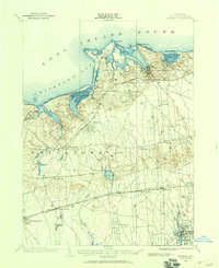
Bridgeport and its industrial waterfront dominate this late nineteenth-century coastal survey, showcasing a landscape defined by tidewater commerce and burgeoning rail connections. The heavy rail lines of the New York New Haven and Hartford Railroad and its Naugatuck Division cut through the landscape, bridging the Housatonic River and anchoring the growth of East Bridgeport and West Stratford. The intricate coastline is dotted with landmarks like Milford Point, Fayerweather Island, and the Light at Black Rock Harbor, while inland mills are represented by features such as Moodys Mill Pond and Berkshire Mill Pond.
Find a feature on this map
44 named features on this map. Tap any name to fly to it.
Don’t see what you’re looking for? This feature index may not catch every label — zoom into the map to look around manually.
Map Details
Editions of this 1891 Bridgeport Map
This is the sole edition of this map. No revisions or reprints were ever made.
Other maps of this area

1889 · Derby
USGS Topo · 1:62,500

1891 · Derby
USGS Topo · 1:62,500

1892 · New Haven
USGS Topo · 1:62,500

1892 · Danbury
USGS Topo · 1:62,500

1892 · Norwalk
USGS Topo · 1:62,500

1893 · Bridgeport
USGS Topo · 1:62,500

1893 · Norwalk
USGS Topo · 1:62,500

1893 · Derby
USGS Topo · 1:62,500

1901 · Northport
USGS Topo · 1:62,500
1902 · Setauket
USGS Topo · 1:62,500